


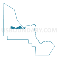
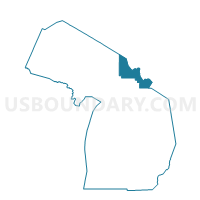
Voting District 0330607000001, Chippewa County, Michigan
About
Outline

Summary
| Unique Area Identifier | 596227 |
| Name | Voting District 0330607000001 |
| County | Chippewa County |
| State | Michigan |
| Area (square miles) | 65.82 |
| Land Area (square miles) | 64.72 |
| Water Area (square miles) | 1.10 |
| % of Land Area | 98.33 |
| % of Water Area | 1.67 |
| Latitude of the Internal Point | 46.44918940 |
| Longtitude of the Internal Point | -84.77109030 |
Maps

Graphs
Select a template below for downloading or customizing gragh for Voting District 0330607000001, Chippewa County, Michigan


Neighbors
Neighoring Voting District (by Name) Neighboring Voting District on the Map
- Voting District 0331556000001, Chippewa County, MI
- Voting District 0331954000001, Chippewa County, MI
- Voting District 0337462000001, Chippewa County, MI
- Voting District 0337754000001, Chippewa County, MI
- Voting District 0338670000001, Chippewa County, MI
- Voting Districts not defined, Chippewa County, MI
Top 10 Neighboring County Subdivision (by Population) Neighboring County Subdivision on the Map
- Soo township, Chippewa County, MI (3,141)
- Bay Mills township, Chippewa County, MI (1,477)
- Superior township, Chippewa County, MI (1,337)
- Dafter township, Chippewa County, MI (1,263)
- Whitefish township, Chippewa County, MI (575)
- Chippewa township, Chippewa County, MI (213)
Top 10 Neighboring Unified School District (by Population) Neighboring Unified School District on the Map
- Sault Ste. Marie Area Schools, MI (20,637)
- Brimley Area Schools, MI (3,276)
- Whitefish Township Schools, MI (575)